
By Dharmesh Prajapati March 20, 2026

NEW DELHI/ISLAMABAD – Just as North India was bracing for an unseasonal March heatwave with temperatures nearing 37°C, the sky has staged a dramatic intervention. A massive, 1,000-kilometer-long rain band has draped itself across South Asia, bringing intense thunderstorms, hail, and a sudden 7°C drop in temperature.
Meteorologists are calling this a “Rare Straight Trough”—a departure from the usual curved Western Disturbances—that is effectively acting as a cooling shield for the subcontinent.
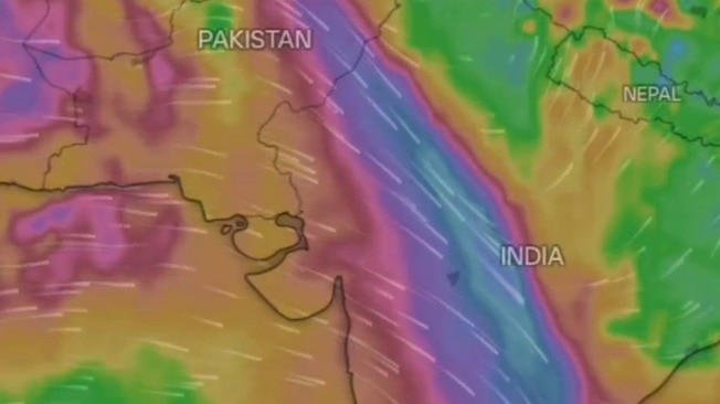
1. The Science of the ‘Straight Line’
Typically, Western Disturbances travel in a curved, swirling pattern as they move from the Mediterranean toward the Himalayas. However, the current system is remarkably linear. This “straight” formation acts like a concentrated atmospheric firehose, amplifying the intensity of moisture delivery.
- The Reach: The band starts in the mountains of Afghanistan, cuts across the plains of Pakistan (where it has already caused significant disruption in Karachi), and extends deep into the Indian heartland, covering Punjab, Haryana, and Delhi-NCR.
- The Power: Because the trough isn’t “leaking” energy through curves, it is spawning fierce winds of up to 90 km/h and intense lightning strikes.
2. Timely Relief or Agricultural Risk?
The arrival of this system is a double-edged sword.
- The Relief: For urban dwellers in Delhi and Lahore, the “May-like” heat of early March has been replaced by a refreshing chill. The dust levels have plummeted, providing a temporary respite from the region’s chronic air pollution.
- The Risk: For farmers in the “Wheat Bowl,” the timing is critical. As I’ve noted in my coverage of the Hormuz food security risk, India cannot afford a crop failure right now. The IMD has issued a Yellow Alert, warning that hailstorms could damage standing Rabi crops like wheat and mustard.
3. The Geopolitical ‘Rain Delay’
Interestingly, the weather is also impacting the conflict zones I’ve been reporting on. The heavy cloud cover and turbulence in the higher altitudes have created “Rough Flying Conditions” on the Delhi-Ahmedabad-Gulf corridors.
As I mentioned in my report on the USS Ford’s technical failures, high-tech systems like drones and electromagnetic launchers are notoriously sensitive to moisture and sudden pressure shifts. This 1,000-km rain band might be doing what diplomacy couldn’t: forcing a temporary “tactical pause” in the regional drone swarms.
4. What to Expect Next
The India Meteorological Department (IMD) predicts that the core of this system will remain active until the night of March 20.
- Critical Window: The next 8 to 12 hours are labeled “critical” for Northern states as the trough tracks eastward toward Bihar and West Bengal.
- Fresh Snow: The higher reaches of Kashmir, including Gulmarg and Sonamarg, have already received 5-6 inches of fresh snow, further delaying the onset of summer.
The Final Word
In a 2026 where “human-made” storms—from the AdSense rejections of news portals to the fires on supercarriers—seem to be everywhere, this natural storm is a reminder of our vulnerability. Whether you are in Valsad or Vladivostok, the weather remains the ultimate sovereign.
Stay indoors during lightning, protect your harvest with hail nets where possible, and keep following Newsforyou.live for real-time updates on this shifting atmospheric front.
Editorial Note
To: News Desk, Newsforyou.live
From: Dharmesh Prajapati, Senior International Correspondent
Subject: Weather Alert – The 1,000-km “Straight” Rain Band
Team, we are tracking a highly unusual meteorological event. While the US-Iran war continues to dominate the geopolitical space, nature has launched its own “saturation strike.” A rare, perfectly linear rain band—stretching 1,000 kilometers from the peaks of Afghanistan through Pakistan and deep into the Indian heartland—is rewriting the March weather script.